Different peoples have come to Greenland on various occasions. The first came from North America and spread over large parts of Greenland. Little is known of their mapping and exploration of the country but it must have been extensive. The first possible documentation comes with the geographer Pytheas (around the year 300 BC). He reached so far north that he was able to confirm his hypothesis that if you travel far enough north, you will eventually reach a place where the sun never sets in summer. Since then, there has been much discussion about how far north Pytheas actually came; was it Iceland or Norway, or did he get Greenland in sight? He called the country Thule. ‘Pytheas’ Thule’ appeared on the world map around the year 140, when the Greek geographer and mathematician Ptolemy drew a world map based on meridians and latitudes, and Thule was placed around 63° north latitude.
The mapping by Claudius Clavus
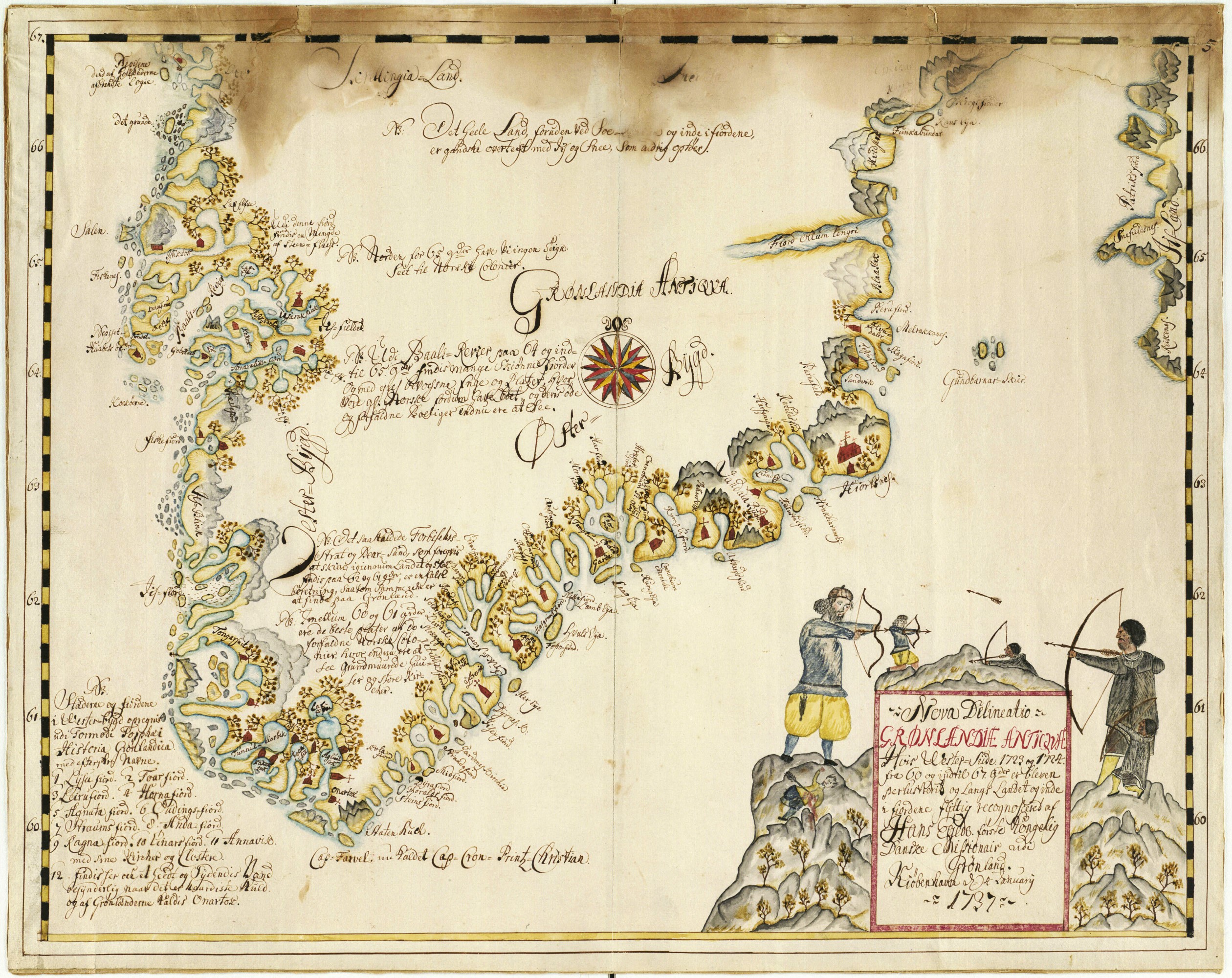
An important milestone was when the Dane Claudius Clavus in 1427 drew the first map featuring both Iceland and Greenland. Clavus had studied Ptolemy’s works, and his map was found together with Ptolemy’s manuscripts. Clavus came up with a surprisingly good determination of Greenland’s southern tip, and for the first time, he put the country on the world map under the Latin designation Gronlandia. However, he was wrong when he drew Greenland as being part of a continuous land mass with Russia.
Mercator’s world map
After Clavus’ map from 1427, the rendering of Greenland over the years remains a bit of a mystery. On his famous world map from 1569, Mercator placed Greenland surprisingly correctly and as an independent island. At that time, there was probably no one who had travelled in or collectively mapped the northern regions of the country. The knowledge base of the world map from 1569 thus remains a mystery.
Mapping between 1576 and 1823
The rest of Europe grew increasingly interested in mapping the Arctic waters. Not least England was persistent in their search for a Northwest Passage – a sea route to the East round the north of America. In 1576, Martin Frobisher almost rediscovered Greenland, and in 1585‑87, his fellow-countryman John Davis made three expeditions and made it all the way to Upernavik.
The exploration of the east coast was far more problematic due to the multiyear ice – or storis (great ice) – which blocked access to the unknown land. From the Danish colonies in the southwest, Peder Olsen Walløe made a journey by skin boat up the coast in 1751‑53. In 1822, William Scoresby found the fjord that came to bear his name, and in 1823, Douglas Charles Clavering and Edward Sabine ventured further north and encountered a till then unknown Inuit tribe on Clavering Island.
Mapping between 1875 and 1913
In 1875‑76, a British expedition led by George Nares successfully managed to reach all the way to the Arctic Ocean and map the eastern part of the north coast. It was not until 1902‑1904 that the ‘Literary Expedition’ led by Mylius-Erichsen was able to map the last part of the west coast. Meanwhile, a number of expeditions led by the American Robert Peary had increased the awareness of the northernmost part of the country, and in 1891, Peary was able to see for himself that Greenland is an island.
The inaccessible Blosseville Coast between Tasiilaq (formerly Ammassalik) and Ittoqqortoormiit (formerly Scoresby Sound) was later mapped by Georg Carl Amdrup and Ejnar Mikkelsen 1898‑1900. The Swede Alfred Nathorst mapped the large King Oscar Fjord. The Denmark Expedition (1906‑1908) put an end to the exploration of Greenland by exploring large parts of Peary Land. After Knud Rasmussen had established his station at the Uummannaq settlement (and later named it ‘Cape York Station’) in 1910, he embarked on a number of expeditions, the Thule expeditions 1912‑1933, which, among other things, mapped the large fjords on the north coast and established the link to the east. With this, virtually the entire coast of the country was known.
In 1878, Arnold Diderich Jensen (Bildsøe) and in 1883, Alfred Nordenskiöld tried to access the ice sheet from the west. In 1888, Fridtjof Nansen chose to access the ice the opposite way at Tasiilaq and travel across the country to Nuuk Fjord. Johan Peter Koch followed the same path in 1912‑1913 from Northeast Greenland to Upernavik, and it now became clear that the inner parts of the country were covered by ice.
FOTOGRAFISK ATELIER, DET KGL. BIBLIOTEK
Further reading
- Hans Egede and the work for the mission service
- Museums of cultural history and heritage
- The colonial period until the war years
- The Inuit culture, precolonial period
- The sea and the fjords
- Traditions and tales
Read more about History in Greenland