
ANINGAAQ R. CARLSEN/VISIT GREENLAND, 2019
Paamiut’s location at the mouth of the fjord Kuannersooq (Kvanefjord) has given the town its Greenlandic name meaning ‘those who reside by the mouth’. Founded as a colony by merchant Jacob Severin in 1742, the town was given its Danish name, Frederikshåb, after then-Crown Prince Frederik – later King Frederik V.
History of Paamiut
When the colony was founded in 1742, the Inuit were already settled on the site as hunting opportunities were good, just as a natural harbour on the lee side is always a benefit to a settlement. During colonial times, whale and seal hunting were the primary livelihood of the town. Paamiut and the settlement of Arsuk formed an independent municipality until the municipal amalgamation in 2009, when Paamiut became part of Kommuneqarfik Sermersooq.

ANINNGAAQ R CARLSEN, VISIT GREENLAND, 2019

GRØNLANDS STATISTIK
The Gulf Stream ensures that Paamiut is an open-water town that can be reached by boat all year round. During some periods, boat traffic can be impeded by the storis (great ice) coming from the south, from the east coast of Greenland.
On the entrance to Paamiut lies an old shipwreck, the trawler Greenland Star, which ran aground in 1984. A contributing cause of the grounding was the fog for which the town is known. The frequent fog is, among other things, caused by Sioraq (Frederikshåb Isblink) north of the town. It is one of the few glaciers in West Greenland that extends all the way to the coast, where it spreads out in about 25 km width.
White-tailed eagles are frequent in the area and have lent their name to the town’s sports association Nattoralik which has proud traditions.
Development of Paamiut took off in the post-war period, and especially as cod fisheries expanded explosively towards the end of the 1950s. In 1967, the largest cod processing plant at that time was constructed here; Paamiut was to be Greenland’s No 1 fishing town.
Meanwhile, the Greenland Technical Organisation (GTO) planned the development of Greenland from Copenhagen, including the urban development of Paamiut. The town was to be one of four main towns in the country where the population was to congregate rather than live scattered in settlements and small settlements. Based on the G-50 and later G-60 development plans as well as the booming cod fishery, the GTO planned and executed a major expansion of Paamiut. The objective was a town of up to 10,000 inhabitants, Greenland’s second largest. Thus, Paamiut was the first town in Greenland to have a full sewer system, and the basic infrastructure with electricity, water and heat supply, roads, housing, school, sports hall and other institutions was developed with this objective in mind. The sports hall in Paamiut was Greenland’s largest until Inussivik in Nuuk was inaugurated in 2002. Much of the urban development was on former plains and wetlands, which the GTO was adept at draining and developing. The GTO’s plans to move people from settlements to selected towns and into large blocks of flats have since met much resistance in Greenland – and in Paamiut.
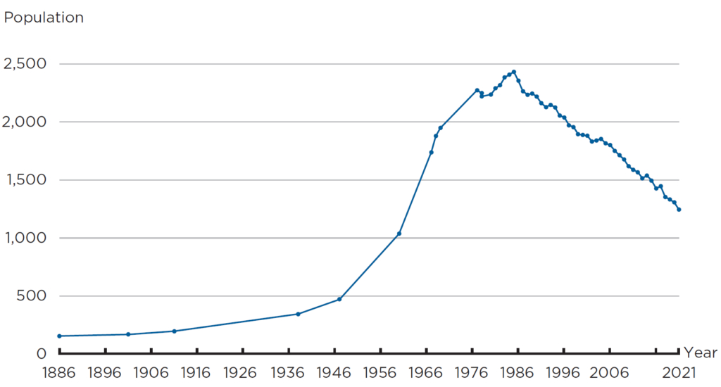
When the cod disappeared from Greenland waters, it hit hard. The settlements of Narsalik and Avigait, south and north of Paamiut, respectively, closed and the town’s development stagnated. Its population peaked in 1988 at 2,433 inhabitants, which was just under 1,000 more than the 1,247 today and thus far short of the 10,000 that was the Ministry of Greenland’s target. Today, the existing building stock and infrastructure are maintained, while worn-out and vacated blocks of flats are demolished.
Infrastructure, trade and industry in Paamiut
The port is the focal point of the town. This is where supplies come in and out, and this is where the fish factory is located. The port, which is large and has good depth, handles cargo, fishing vessels and passengers by boat or ship and also disposes of a marina with several pontoon bridges. The coastal ship calls at Paamiut twice a week in northbound and southbound directions, respectively. Royal Arctic Line calls at the town weekly with freight and food.
Until 2007, when Paamiut got its own airport north of the town, it was served by helicopters via the heliport in the middle of the town. The airport is primarily served by Air Greenland with Dash 8 aircraft and fixed routes to Nuuk in the north and Narsarsuaq in the south.
The fish factory has survived times of hardship by making continuous adaptations, and is operated by Royal Greenland in 2021. The factory mainly processes crab, cod and lumpfish roe, all seasonal productions. In order to secure the 65 or so jobs throughout the year, Royal Greenland also started to produce Greenland halibut fillets in 2020.
In addition to the public workplaces, shops, hairdresser and fish factory, there are some small trade and contractor firms and a small hotel. The townspeople, the municipality and the Self-Government are working purposefully on commercial initiatives that can benefit and develop the town. The port and the airport play a key role. Most promising is the export of clean drinking water from the hinterland, while the idea of using the town’s port as a transit port for international navigation and transhipment of cargo is probably some way off. With better traffic links and marketing, tourism can be developed and expanded.
The primary school in Paamiut is called Atuarfik Tuiisaq and the school’s current buildings were inaugurated in 1972. A few years later, there were nearly 800 pupils – a contrast to the barely 200 pupils in 2021. The town’s public library is found at the school.
The town houses a branch of the Imarsiornermik Ilinniarfik (Greenland Maritime Center), which provides basic training and courses in the maritime and fishing field. School uptake is declining.

ASIAQ, 2022
Further reading
- Housing
- Infrastructure
- Ittoqqortoormiit
- Kommuneqarfik Sermersooq
- Nuuk
- Self-Government
- Tasiilaq
- The five regional municipalities
- Towns and settlements
Read more about the Municipalities and towns in Greenland
